A Tornado Watch has been issued for several counties across metro Atlanta and North Georgia as a powerful storm system moves through the region early Monday morning.
The Tornado Watch highlights the potential for severe thunderstorms, damaging winds, and rapidly developing tornadoes.
Meteorologists warn that residents should remain alert as the Tornado Watch remains active until 10 a.m. ET, bringing rapidly changing weather conditions, heavy rainfall, and the possibility of brief tornadoes before a dramatic drop in temperatures later in the day.
Severe Weather Threat Across North Georgia
The Tornado Watch covers a wide area of North Georgia, including multiple counties around the Atlanta metropolitan region. The weather system is producing severe thunderstorms capable of generating intense wind gusts, lightning, and torrential rainfall.
According to the National Weather Service, severe thunderstorm warnings were issued for counties such as Carroll, Cobb, and Paulding. Forecasters emphasized that the current Tornado Watch environment is highly unstable, meaning storms can quickly rotate and produce tornadoes with very little warning.
Residents in metro Atlanta and surrounding communities have been advised to closely monitor weather alerts as the storms move eastward throughout the morning.
Spin-Up Tornado Risk and Wind Damage
One of the biggest concerns during the Tornado Watch period is the threat of “spin-up” tornadoes. These types of tornadoes can develop rapidly within strong storm lines and often occur with minimal advance warning.
Meteorologists explained that severe thunderstorm warnings during this Tornado Watch should be treated with the same level of caution as tornado warnings. Storms currently moving through North Georgia are capable of producing wind gusts up to 60 mph, which could cause fallen trees, damaged structures, and power outages.
Earlier reports from the Dalton area indicated damage linked to a storm system where a tornado warning had been issued earlier in the morning.
Counties Under the Tornado Watch
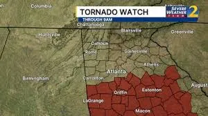
The Tornado Watch remains active until 10 a.m. ET and affects numerous counties across the region. Areas included in the watch are Butts, Carroll, Cherokee, Clarke, Clayton, Cobb, Coweta, DeKalb, Douglas, Fayette, Forsyth, Fulton, Gwinnett, Hall, Haralson, Heard, Lamar, Meriwether, Newton, Oconee, Paulding, Polk, Rockdale, Spalding, Upson, Walton, White, and several others.
Officials say residents living within the Tornado Watch area should be prepared for sudden weather changes and potential emergency alerts if tornado warnings are issued.
Sharp Temperature Drop After Storms
Once the storm system moves out of the region later Monday morning, the Tornado Watch conditions will give way to an unexpected and dramatic temperature change.
Meteorologists say a strong cold front will sweep into North Georgia behind the storms, replacing warm and humid air with much colder conditions. Afternoon temperatures may drop into the 40s across metro Atlanta.
In some areas of far North Georgia and northern suburbs, the sudden temperature shift could even lead to light snow flurries later in the day. However, forecasters do not expect any significant accumulation or travel disruptions from the wintry mix.
Potential for Stronger Tornadoes
Weather experts warn that atmospheric conditions during the Tornado Watch could support stronger storms in isolated areas.
Meteorologist Alex Forbes noted that warm, moisture-rich air moving north from the Gulf of Mexico is fueling the storm system. This environment increases the chances that isolated storms ahead of the main line could intensify.
While not guaranteed, there is a possibility that at least one tornado in the southeastern region could reach EF-2 strength if conditions align during the Tornado Watch period.
Safety Tips During a Tornado
When a Tornado Watch or warning is issued, safety preparations are critical. Residents should take the following precautions:
Move to a secure shelter:
Go to a basement, storm shelter, or interior room on the lowest level of a sturdy building.
Protect your head and neck:
Use blankets, mattresses, helmets, or your arms to shield yourself from flying debris.
Avoid vehicles and mobile homes:
These structures provide little protection during tornadoes. Seek stronger shelter immediately.
Stay updated on alerts:
Monitor weather apps, television broadcasts, and emergency radio updates for the latest information.
If caught outside:
Leave your vehicle and lie flat in a ditch or low area while covering your head.
Weather Outlook for the Week
After the severe storms associated with the Tornado Watch move out Monday morning, the region will experience a brief return of winter-like conditions just ahead of St. Patrick’s Day.
Cold winds may bring wind chills into the teens and 20s by Tuesday morning. However, the chill will not last long. Forecasters predict a rapid warming trend later in the week, with temperatures potentially reaching 80 degrees by the weekend as spring weather returns.
The Tornado Watch across metro Atlanta and North Georgia highlights the unpredictable nature of severe weather systems in the region. Residents should stay alert during the morning storm period due to the possibility of damaging winds and rapidly developing tornadoes.
After the storms pass, the area will experience a dramatic shift from warm, humid conditions to a brief winter chill before temperatures rebound later in the week. Staying informed and prepared remains the best way to stay safe during severe weather events.